MDSD Session
I listened to a session on SOA platform and later got to a workshop on EMF and large models. I got there just by an accident, resulting from the discussion with guyes from Gentleware and SAP. We spoke in a lunch discussion about the problems of EMF. Then Axel Uhl just invited me to participate and I got probably to the most interesing part of the summit. It was very informative and I spent several hours with the MDSD gurus like Ed Merks, Marcus Voelter, Bernd Kolb, three gyes from SAP, formely Interactive Objects, three gyes from Gentleware and a couple of persons I don’t know. The subject of the workshop was the discussion of large models, and problems and issues on the management and infrastructure. After the long dialog on needs and nice-to-haves the group agreed on a need of creation of an open-source EMF-based repository, in order to identfy the opporunities of what is available today and pain-points of existing solutions. The open source nature should foster the consolidation of a spread knowlegde and experience on EMF in a single project. Later, I visited an excited demo of Ed Merks on new features of EMF.
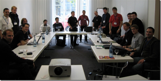
Thanks to Ed, we all got a wonderful picture of all us…
lightbox[post]
BIRT Session
Other intersting sessions visited were the BIRT-related session. It seems that this Eclipse project gets adult. I was really impressed on the variety of features and especially the number of solutions to real world problems I often tried to solve during my industrial activities. It seems that BIRT can be seen as a next level open source reporting tool, that offers a good foundation for further in-enterprise reporting.

Google’s portal is now called iGoogle
Usecase 1.2
As already mentioned in one of the previous posts I’m playing around with GPS technology, trying different use cases. One of them is tracking own position using a GPS Mouse and cell phone. The minimum requirement was to track position data (x,y,z) and store it on a flash card inserted in the cell phone, connected to GPS receiver via Bluetooth. After a short search on the Internet I found GPS Track (version 1.1) free software, packaged as Java Middlet for use on any J2ME compatible cell phone.
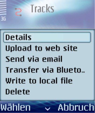
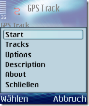
After the simple installation the basic setup on the cell phone have to be executed. The main menu of the software is structured as folows:
- start: start the tracking / changed to stop, if tracking is running
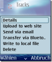
- tracks: manipulation of already recorded tracks (track menu)
- details: name, records(number of points), memory usage
- upload to web site: to upload to the http://qcontinuum.org/map and to be displayed as an overlay on the Google Maps
- send via email: Send the track file by E-Mail (Google Earth .kml, GPS Exchange .gpx, Excel .csv)
- transfer via bluetooth: Send the track file by Bluetooth (Object-Push) (Google Earth .kml, GPS Exchange .gpx, Excel .csv)
- write to local file: Write the track file locally (Google Earth .kml, GPS Exchange .gpx, Excel .csv)
- delete
- options: basic options on units, tracks and backlight
After the basic setup and the established connection between the GPS Track and the Bluetooth device (the connection established is stored, so you need to setup only once) the tracking can be started. During the tracking several screens are available and can be switched using options->next.
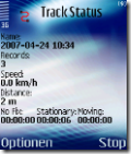
Track Status
- Name: Name of the track, created from the recording date and time
- Records: number of records (measurements)
- Speed: current speed
- Distance: track length from the beginning of the measurement
- No Fix: time during tracking, the receiver is not able to determine its position
- Stationary: the receiver can determine its position and is not moving
- Moving: the receiver can determine its position and is moving
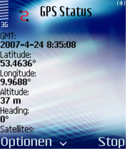
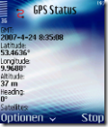
GPS Status
- GMT: current time (satellite time?)
- Latitude, Longitude, Altitude: current coordinates
- Heading: direction of moving
- Satellites: number of satellites from that the signal is received
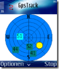
GPSTrack
An embedded compass (also available separately without GPS at http://qcontinuum.org/compass/) showing the position of the Sun/Moon. In addition the position of the satellites is displayed on the compass.
Summary
I played around with GPS track and recorded several tracks. The tracks varied from short to pretty long (~70 km). Basically, I’m satisfied with the functions the software offers to me. Because of the source code is available, i’ll have a look on it and may be will refactor some UI or possible drill one or another additional feature in to it. Especially the UI is very primitive, so I think that the information can be presented much more compact, using one screen instead of three.